![[Traveling Around Taiwan in Fifteen Days] Coastal Highway to Taitung](https://www.anyonetrip.com/uploads/202302/13/9a6f92660ea6b43d.webp)
Friends who have read my last travel note will definitely remember that we walked back and forth along Huadong Rift Valley Highway No. 9 yesterday, and today we will go to Taitung along Coastal Highway No. 11. Highway 11 is at the foot of the eastern edge of the Coastal Mountains, with the vast Pacific Ocean on the other side. Most of the residents living along this road are Amis and Puyuma. Today, the aborigines have also moved out of the mountains. It is hard to tell from the clothes, but the traces of the aborigines can be vaguely seen in the appearance. For example, the singer Zhang Huimei is a Puyuma. This section of the coastline is quite different from the seaside we used to see. Due to the collision of the Philippine plate and the Eurasian plate, two types of landforms appeared on the Pacific coast of eastern Taiwan. One is the volcanic rock landform deposited on the shore by volcanic eruption, and the other is the sea erosion landform. The orogeny of several million years ago raised Taiwan Island as a whole, and the seabed rocks were pushed out of the sea to form faults. The fault zones are vulnerable to erosion. Under the erosion of waves, rain, monsoons and the continuous rise of the crust, strange rocks and monsters are formed. stone. In Taiwan, the high mountain area generally refers to the altitude above 1,200 meters, because ancient marine fossils can be found below this altitude.
Taiwan topographic map
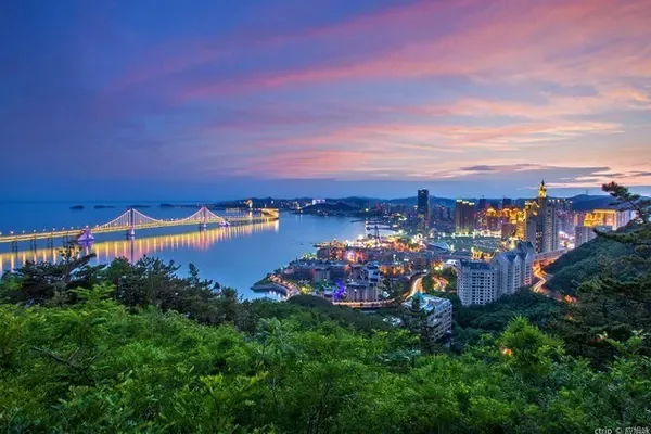
Starting from Hualien City, we first came to the top of the mountain near Yanliao Village at the northern end of the Coastal Mountain Range. Standing on the top of the mountain, you can look towards the Huadong Rift Valley to the west and the Pacific Ocean sunrise to the east. On the top of the mountain, there is a five-star hotel under the American Farglory Group called Farglory Pleasure Hotel. It is said that the standard room costs about 2,000 yuan per night. The scenery is indeed beautiful living here, but it is not so inconvenient to go to the city to visit the night market.
Hualien City at the foot of the mountain
Farglory Hotel on the top of the hill
the pacific below the mountain
Overlooking Huadong Rift Valley
About 60 kilometers south from here is the first viewing area we went to - Shimen Banshaojiao. A huge headland protrudes into the sea and divides the nearby coast into two small bays in the shape of a "w", with some black volcanic rocks scattered on the shore. The waves kept beating on these reefs and receding back again and again. Not far away, there is a small lighthouse that is not high enough to guide fishing boats, but it is now abandoned. A squad of troops stationed here in the past has also withdrawn, but there is still a camouflaged radar on the mountain across the road.
Shimen Banshaojiao
Not far ahead is Shitiping Beach. The seashore stretching for about one kilometer is covered with black and gray strange rocks and rocks, and the top of the rocks is covered with a layer of gray-white tuff. This is a formation of pyroclastic rock formed by eruptions of submarine volcanoes long ago. The rock slopes towards the sea in the southeast at a certain inclination angle, forming a stone ladder shape. I saw an old man sitting on a rock fishing. He came forward to inquire and learned that these volcanic rocks are very loose and have many underwater holes. Many fish like to live in such places, so fishing here may be very rewarding. There are also diving enthusiasts playing deep diving and watching fish in this area, which is really bold. You must know that 100 meters away from the shore here is a trench as deep as 1,000 meters. There is a fishing port next to the scenic spot, which is the largest fishing port in Taiwan using the traditional fishing method of "dart swordfish".
Going further south is the last scenic spot in Hualien County, the Tropic of Cancer Sign Tower located on the seashore in Fengbin Township, Hualien County. This symbol tower is more distinctive than the one seen yesterday, with a slender conical tower topped with a ball. The whole body of the tower is white, and there is a slit on the center line in the east-west direction, which means that the Tropic of Cancer passes through this slit. The position of the Tropic of Cancer is about 23 ° 26' north latitude (according to the observation of scientists that the position of the Tropic of Cancer changes every year), which is the latitude line at which the sun can directly reach the northernmost part of the earth every year. On the day of the summer solstice every year, the sun shines directly on the Tropic of Cancer, and there is no "immediate effect" at noon. The Tropic of Cancer is also the dividing line between the tropics and the northern subtropics. When you stand in front of the tower with your feet separated from the seam of the tower, you are standing on the earth's tropics with one foot and the other foot in the earth's northern subtropics.
Tropic of Cancer sign tower by the sea
Go further south and enter Taitung County. There is also a scenic spot by the sea called Sanxiantai, a sea-crossing bridge links a small island not far from the shore. It was noon and everyone felt hungry, so they gave up this scenic spot and went directly to Fanzhe. Brother Lin said that the buns in Donghe Township, Taitung are very famous, so he went straight to a famous local bun shop. The small shop is small with only four or five tables and it is not full yet, but there are quite a few people packing and taking away, and several salespersons are very busy. In addition to meat buns, there are several kinds of buns with sweet fillings, including coconut, taro, and steamed buns. To be honest, the steamed buns here are not as good as those in Tianjin’s “Goubuli”, but for Taiwanese who usually eat rice, this is a very good steamed bun and steamed bun.
After eating enough, Brother Lin said, let's take you to see the macaques in Taiwan. I thought there was some sort of safari park nearby. He said, no, it was a wild monkey. The car drove on No. 23 Dongfu Highway. This road is the road from Donghe Township, Taitung to Fuli Township, Hualien. It is also the horizontal connection line between Highway 9 and Highway 11. The line crosses the coastal mountains. The coastal mountains are not so high and steep, and the car is moving forward in a valley. There is a rest area about ten kilometers away from Mizoguchi, and passing vehicles often drop some food after resting. The monkeys on the mountain will not go back to the forest after they have eaten the sweetness. They will wait by the side of the road. As soon as your car stops, they will surround you, and some even climb on the roof of your car to play leisurely. Fortunately, the monkeys here are much more civilized than the ones in Mount Emei, and there are no situations where they stop and grab food. When the car left, they squatted in a row on the roadside guardrail to watch the car leave.
No. 23 Dongfu Highway
Scenery along the way
There is a strange slope in Shenyang, Liaoning, everyone knows it. There is also a special landscape here in Taitung - "water flows upwards". There is a canal beside the road that looks higher in the west and lower in the east, but the water in the canal flows westward. Is my vision wrong? Picking up a leaf and throwing it into the ditch does indeed float westward. There are many theories to explain this phenomenon, but I still believe in the theory of visual difference. If I go there next time, I will definitely bring a level ruler to measure which end is higher and which end is lower.
water flow up
betel nut on tall tree
Past the "Water Up" Coast Range the end is almost over. There are two scenic beaches near the end of the coastal mountains, one is called Jialulan Coast, and the other is called Xiaoyeliu. There is not much to see in Jialulan. It is said that it is a construction waste dump. In recent years, a large lawn has been laid and some artificial landscapes have been set up. People alighting from the tourist buses scramble to take photos in front of these man-made landscapes. Xiaoyeliu is still very good. During the orogenic movement 6 million years ago, Xiaoyeliu was also lifted out of the sea in this area. Due to the difference in softness and hardness between the rock layers, after years of sea erosion, the hard ones are convex and the soft ones are concave. A typical sea erosion landform. The rocks here are honeycomb-like, mushroom-like, and animal-like, and later weathered windows constitute a colorful rock formation landscape. In Keelung, Taiwan, there is a sea-erosion landscape that is larger than this one. Because it is located near a village called Yeliu Village, the one in Keelung is called Yehliu Geopark, and this place is called Xiaoyeliu. When we arrived at Xiaoyeliu, it was high tide, and the waves slapped on the reef and made a loud "pop, pop" sound, which made people feel the power of the sea. Human beings should respect nature with this true heart.
There are very rich hot spring resources on the bank of Zhiben River in Beinan Township, Taitung County. We stayed at Dongtai Hot Spring Hotel in Zhiben Hot Spring that night. As soon as I walked into the hotel lobby, there was a strong sulfur smell. The faucet in the bathroom in the room was already rusty, and the faucet was marked with "non-drinking water". There was a large bucket of pure water in the room. All this is enough to prove that the hot springs here are by no means heated by boilers. After dinner, I took a dip in the hotel's outdoor hot spring pool. The thermometer by the pool showed that the water temperature was 41°C, which was refreshing! Washed away the fatigue of the ten-day journey. A standard room in Dongtai Hotel (including breakfast) costs NTD 2,200 per night, including two vouchers for outdoor hot springs worth NTD 300. Please note that you need to wear a swimming cap to take a hot spring here. I only brought swimming trunks but no swimming cap, so I had to spend 100 Taiwan dollars to buy a low-end swimming cap to survive.
Dongtai Hot Spring Hotel and Hot Spring Pool
Forest Park next to the hotel
After passing through Taitung County, Coastal Highway No. 11 and Huadong Rift Valley Highway No. 9 merge into one. The mountains on the west side of the highway are no longer coastal mountains but central mountain ranges. The sea to the west is still the vast Pacific Ocean. . On the way to Kenting the next day, I also visited a small railway station, Duoliang Station, built on a cliff near the sea. Below the platform on one side of the railway station is the sea, and the platform on the other side is close to the mountain. The trains between Kaohsiung and Hualien pass here every day, but they don't necessarily stop.


![[Traveling Around Taiwan in Fifteen Days] East Rift Valley of Flowers](https://www.anyonetrip.com/uploads/202302/13/d00c13ca0882ab1b.webp)